WSO Menu

Promoting the enjoyment, study, and conservation of Wisconsin's birds.

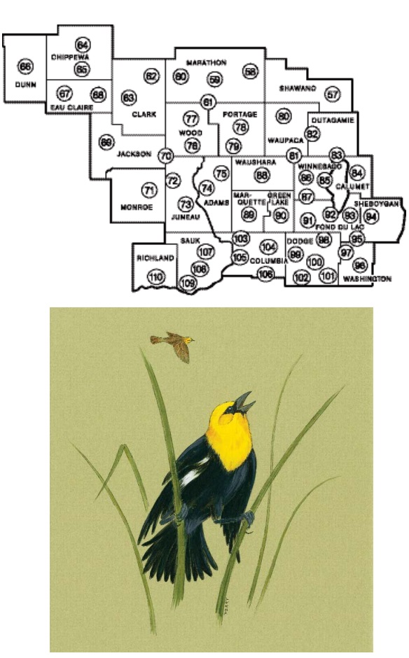
This section consists of Central Wisconsin. The areas covered are highlighted in the map below with the numbers corresponding to articles in the table of contents below and include parts of Shawano, Marathon, Wood, Portage, Clark, Chippewa, Dunn, Eau Claire, Jackson, Monroe, Juneau, Adams, Waupaca, Winnebago, Outagamie, Calumet, Waushara, Marquette, Green Lake, Fond du Lac, Sheboygan, Washington, Dodge, Columbia, Dane, Sauk, and Richland Counties.


This content is restricted to WSO members. Please click below to log in first.

If you wish to sign up for a WSO membership, please click here.
 

 central 01
  1. Shawano County
  2. Eastern Marathon County
  3. Central Marathon County
  4. Western Marathon County
  5. Mead Wildlife Area - Marathon, Wood and Portage Counties
  6. Eastern Clark County
  7. Western Clark County
  8. Northern and Central Chippewa County
  9. Chippewa Falls Area - Chippewa County
  10. Dunn County
  11. Western Eau Claire County
  12. Eastern Eau Claire County
  13. Black River State Forest - Jackson County
  14. Bear Bluff Area - Jackson and Wood Counties
  15. Monroe County
  16. Meadow Valley - Juneau County
  17. Necedah National Wildlife Refuge - Juneau County
  18. Petenwell Flowage - Adams and Juneau Counties
  19. Adams County
  20. Southern Wood County
  21. Northern Wood County
  22. Stevens Point - Portage County
  23. Buena Vista Grasslands - Portage County
  24. Northern Waupaca County
  25. Fremont - Weyauwega - Waupaca - Waupaca and Winnebago Counties
  26. Shiocton - Black Creek, Hortonville - New London - Outagamie and Waupaca Counties
  27. Fox Cities Region - Outagamie and Winnebago Counties
  28. Calumet County
  29. Oshkosh - Winnebago County
  30. Terrell's Island - Winnebago County
  31. Rush Lake - Winnebago County
  32. Waushara County
  33. Marquette County
  34. Green Lake County
  35. Western Fond du Lac County
  36. Northern Fond du Lac County
  37. Eastern Fond du Lac County
  38. Western Sheboygan County
  39. Kettle Moraine State Forest - Northern Unit - Fond du Lac, Washington and Sheboygan Counties
  40. Washington County
  41. Theresa Marsh - Dodge and Washington Counties
  42. Horicon Marsh - Dodge County
  43. Beaver Dam - Fox Lake Region - Dodge County
  44. Beaver Dam River - Dodge County
  45. Lower Rock River Area - Dodge County
  46. Chub Lake Region - Dodge County
  47. Portage - Columbia County
  48. Mud Lake - Poynette - Columbia County
  49. Lake Wisconsin - Columbia County
  50. Arlington Prairie Area - Columbia and Dane Counties
  51. Baraboo - Sauk County
  52. Honey Creek - Sauk County
  53. Southwestern Sauk County
  54. Southern Richland County

central end