WSO Menu

Promoting the enjoyment, study, and conservation of Wisconsin's birds.

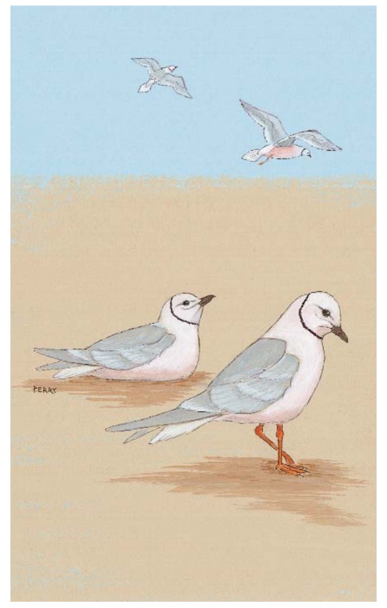
This section consists of Northern Wisconsin. The areas covered are highlighted in the map below with the numbers corresponding to articles in the table of contents below and include parts of Douglas, Bayfield, Ashland, Iron, Vilas, Forest, Florence, Marinette, Oconto, Langlade, Oneida, Price, Sawyer, Washburn, Barron, Rusk, Taylor, and Menominee Counties.


This content is restricted to WSO members. Please click below to log in first.

If you wish to sign up for a WSO membership, please click here.
 

 nor 01
  1. Douglas County
  2. Superior - Douglas County
  3. Brule River - Douglas County
  4. Southern Bayfield County
  5. East-Central Bayfield County
  6. Northern Bayfield County
  7. Northern Ashland/Bayfield County
  8. Greater Ashland Area
  9. Clam Lake Area - Ashland County
  10. Southeastern Ashland County
  11. Southern Iron County
  12. Central Iron County
  13. Northern Iron County
  14. Western Vilas County
  15. Eastern Vilas County
  16. Northern Forest County
  17. East Central Forest County
  18. Western Florence County
  19. Eastern Florence County
  20. Northern Marinette County
  21. Nicolet National Forest - Oconto, Forest and Langlade Counties
  22. Eastern Oneida County
  23. Western Oneida County
  24. Northeastern Price County - Chequamegon - Nicolet National Forest
  25. Park Falls - Price County
  26. Sawyer County
  27. Washburn County
  28. Rice Lake - Cumberland - Turtle Lake - Barron County
  29. Blue Hills - Barron, Sawyer and Rusk Counties
  30. Southwestern Rusk County
  31. Northern Rusk County
  32. Taylor County
  33. Lincoln County
  34. Langlade County
  35. Northern Oconto County
  36. Menominee County

nor 07